 |
The relief of the country is diverse, including vast lowlands, planes, low hills, high and low mountains, valleys, river basins and deep gorges. The surface structures were formed during different geological eras. The oldest in terms of geological classification are the Moezian Platform (the Danubian Hilly Plane) and the Rila Massif and the Rhodopes. The undulating system of Stara Planina and Sredna Gora mountains and the Sub-Balkan Valleys date from a later geological |
|
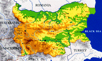
The average altitude of Bulgaria is 470 m. Over 2/3 of the territory is situated at an altitude of 600 m, i.e. lowlands, planes and low hills prevail. The lowlands (up to 200 m) take up 30% of the territory, the planes and the low hills (200-600 m) - 40%, the low mountains (600-1000 m) - 16%, the medium high mountains (1000-1600 m) - 10%, and the high mountains (over 1600 m) - 4%. A typical feature of the relief is that its structural units alternate from north to south and extend (also diminishing in height) from west - north-west to east - south-east. In the northernmost part of Bulgaria, to the south of the Danube River, lies the Danubian Hilly Plane, the largest plane in the country. To the south it reaches the Fore-Balkan, to the west - the Timok River, to the east - the Black Sea. Its highest point (502 m) is in the region of the Shoumen Plateau. From the east to the west the relief changes from lowlands-plateau to uplands-plateau. The Fore-Balkan is a fore mountain of Stara Planina, from which it is separated by a system of gorges, defiles and valleys. It lies to the south of the Danubian Hilly Plane stretching from Vrushka Chouka Hillock to the Black Sea. The mountain rises to its highest point in the Vasilyovska Mountain - Vasilyov Peak (1490 m), and its average altitude is 364 m. In the relief of the Fore-Balkan longitudinal mountain rising grounds, divided by wide valleys, prevail. The mountain range of Stara Planina lies between the Belogradchik Pass and Cape Emine on the Black Sea; to the south it borders on Sofia Valley and the Southern Balkan Valleys. Its length is approximately 530 km, its width - 15-20 km and its medium altitude - 722 m. The range reaches its highest elevation in the Troyan-Kalofer Mountain - Botev Peak (2376 m). To the south of Stara Planina and almost parallel to it the Sredna Gora Mountains lies. It is connected to Stara Planina by means of the cross-thresholds Gulubets, Koznitsa, Krustets and Mezhdenik. Its length is about 285 km, its width - 50 km and its average altitude is 608 m. Its highest point is Golyam Bogdan Peak (1604 m). Between Sredna Gora, the Rila Massif and the Rhodopes there lie the low mountains Golo Burdo, Chirpan Hills, the massive mountain domes of Vitosha and Sakar, the isolated hills of Sveti Iliya, Manastir, Bakadzhitsite, etc. The upper Thracian and Bourgas valleys, the valleys of Pernik and Radomir lowlands are situated between these hills. The Rila Massif and the Rhodopes are the highest on the Balkan Peninsula. They consist of the Rila Mountains (highest point - 2925 m), Pirin, the Rhodopes and the mountain group of Osogovo-Belasitsa. In the Quaternary Rila and Pirin were covered with glaciers; at 2200 m altitude there can be found numerous cirques, glacial planes, moraines and beautiful cirque lakes. The sharp rocky peaks lend these mountains an alpine view. The mountain massif of the Rhodopes has almost square outlines and levelled ridges. It is characterized by the alternation of high long rising grounds and narrow, deeply cut in valleys and ravines. There are numerous Karst formations - caves, gorges, rock phenomena (in the regions of Trigrad, Velingrad, Dobrostan, Peshtera and Arda). In the eastern part of Bulgaria, by the Black Sea Coast, there are well outlined wide beaches. These occupy approximately 130 km of the Bulgarian Black Sea coast (378 km). The Kamchiya- Shkorpilovtsi Beach Line is the longest (12 km). These beaches are wide and strewn with fine sand. Bulgaria is situated in the southern part of the temperate climatic zone of Europe. The territory of the country is subject to the influence of the Atlantic Ocean from the west, and to the influence of the continental part of Central and Eastern Europe from the north-west and the north-east. The climate of Bulgaria is generally defined as temperate continental with well expressed transition to the south of Stara Planina. In the southernmost regions of the country the influence of the Mediterranean is felt. The influence of the Black Sea is localized along a narrow strip (10 - 30 km) in Eastern Bulgaria. In the mountainous regions at an altitude above 1000 m a mountainous climatic zone is differentiated with relatively low temperatures, heavy rainfall and continuous snow retention. The average annual temperature of the air in Bulgaria is 10,5 C. The lowest reading, -38,3 C, was taken in Trun in 1947, the highest, +45,2 C, in Sadovo in 1916. Winds vary in direction and velocity, relatively constant being the north-west and the west. These cause warming up in spring and bring rainfall in summer, often accompanied by thunder. Comparatively frequent is the north-east wind bringing dry continental air masses - cold in winter and hot in summer. The average annual rainfall range is between 450 - 1300 mm, the larger quantity falling over Western Bulgaria and the high mountains. The heaviest rains fall in May and June, but in the high mountains the precipitation is in winter. The snow cover lasts 10 days along the Black Sea coast, but more than 200 days in the high mountains. The complex relief structure and the small territory of Bulgaria do not create conditions for big rivers. The variety of relief and climatic conditions account for a comparatively dense and unevenly distributed river network. Most rivers in Bulgaria spring from its high mountains and flow into the Black Sea (predominantly through the Danube River) and the Aegean Sea. The catchment basins of these rivers are small - the biggest one is the Maritsa River basin. In Bulgaria there are 526 rivers that are more than 2,3 km long. The longest one is the Iskur - 368 km. Bulgaria is rich in mineral waters, with more than 600 natural springs and more than 370 drillied mineral sources. The temperature of the water ranges from 8 to 101,4 oC (in Sapareva Banya). The natural lakes in Bulgaria are comparatively few. The biggest are along the Black Sea - the lagoon lakes of Alepou, Arkoutino, Pomorie, and the firth lakes of Beloslav, Bourgas, Varna, Shabla. Most numerous (more than 360) are the high-mountain alpine glacial lakes in Rila and Pirin. These are situated mainly in cirques at an altitude of 1900 - 2400 m. The lakes and the swamps along the Danube have been drained with the exception of Sreburna Lake which is a part of a reserve. Numerous dams have been built as parts of hydrosystems and hydrojunctions - Iskur, Arda, the Batak Hydropower System, Dospat-Vucha, Belmeken-Sestrimo, and also about 2000 small dams. |
|
 My name is Radostina Georgieva, "Roddy".
I live in California.
I enjoy travelling, reading books, listening to music, going to the movies.
I am constantly looking for ways to challenge myself, learn, and grow.